Archive
Game Environment Cartography
Developing a map for an Interactive Fiction environment can be challenging especially if the game is based on real-world geography, as is the Historical Williamsburg Living Narrative. A large part of the value of this game is the historical accuracy–which not only includes the events of the time but the geography and architecture as well. In designing the game map, I am considering external landscape and building floor plans separately, and here I describe the process by which the external landscape portion of the game map was developed.
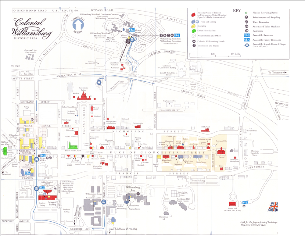
I started working from the map provided by the Colonial Williamsburg Foundation for guests visiting the city. Below is a scanned version of that map, already partially “cleaned up” (that is, much of the extraneous information–modern buildings, bus route lines, restroom symbols, etc.–have already been removed). After working with this map for a brief period of time, I found a few characteristics I didn’t like. Most significantly, there wasn’t a sufficient level of detail regarding building shapes and grounds, and the relative sizes, locations, and distances between buildings wasn’t accurate enough for me to use in creating descriptions.
At this point I changed my approach. In order to ensure fidelity to the actual physical layout of Williamsburg, I decided to use satellite imagery for the initial layout work. Google Maps provided excellent resolution from the Governor’s Palace in the north to the Public Hospital in the south, and the College of William and Mary in the west to Christiana Campbell’s Tavern in the east. The city’s overall layout was depicted quite clearly.
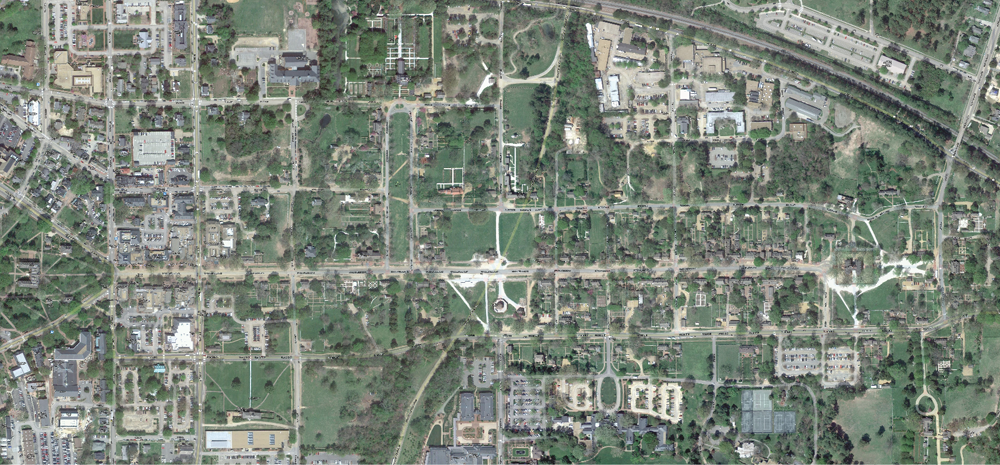
Once I had an accurate map from which to work, I was able to select the significant buildings, associated grounds, and pathways between that the player would be using. I superimposed this image on top of the map, and this gave me the level of detail I wanted for development.

Peeling away the city map, this is what the initial pass at the game map looks like. While this map contains all the information needed to create accurate location descriptions (for example, it will be important to note the distance of the College of William and Mary from the city proper), this version of the map is a bit difficult to work from in building the Interactive Fiction navigation scheme. For that task, a logical map is more appropriate.

This logical map was built from the physical line map (above), connecting locations using only the eight compass directions, and not taking into consideration the sizes of buildings or their actual distance from each other. Also, no assumptions can be made between “nodes” in the map below if they are not connected by a direction line. In other words, if a node is to the west of another node, but they are not connected by an east-west line, they may not be precisely east and west of each other. This map simplifies and compresses the physical map information for ease of navigation programming. The yellow nodes represent place locations where the player may go, while the blue nodes represent buildings or structures that have additional rooms or internal locations not depicted here. Those additional locations will be represented in further mapping exercises.
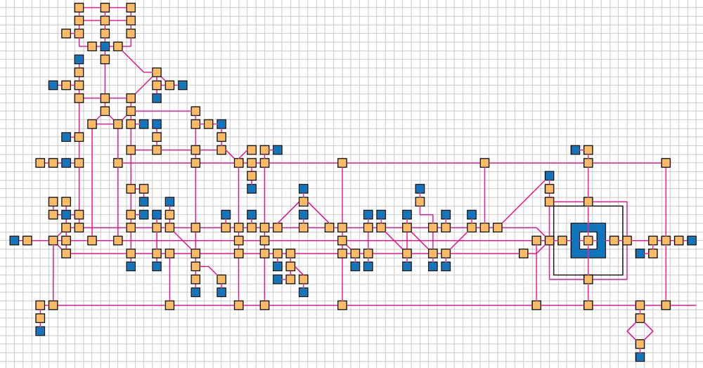
By using this logical map along with the visual information obtained from the line map superimposed from the Google satellite image, I will be able to create rich in-game descriptions of the physical Williamsburg environment. For example, an east-west running path on the logical map may actually be a long, curved road on a hilly slope, and that level of detail will be captured in the game for a rich and hopefully satisfying experience.
142…
… is the number of external location “nodes” in the Historical Williamsburg game map. Locations are defined simply as anyplace the player character is able to stop and examine the surroundings during the game. These locations include spots such as doorways, gardens, and street intersections.
This number does not include any building interior room locations. Expect that the total number of game locations will be significantly higher.
The Horizon Report > 2013
Since 2002, the NMC (New Media Corporation) has been publishing a series of Horizon Reports meant to provide insight into the up-and-coming technologies that would have impact in education. In the Horizon Report > 2013 for Higher Education, one of the impact categories identified is “Games and Gamification.” The Historical Williamsburg Living Narrative project was cited as an example in the report.
As game play continues to be a major focal point of discussions among educators, some believe that gamified learning is merely a trend, and carries the danger of immediately disenchanting students if executed poorly. To negate this challenge, more universities are partnering with organizations and companies skilled in game design to develop and integrate games that are relevant to the curriculum and to students’ lives. Games and gamification in education include a broad set of approaches to teaching and learning, and when implemented effectively, can help with new skill acquisition while boosting motivation to learn.
Download a copy of the Horizon Report > 2013 for Higher Ed and check out the Historical Williamsburg Living Narrative entry on page 22, under the category of History.
