Archive
Latest Williamsburg Game Map
I’ve been working on updates to the building interior locations. This map reflects the latest navigation scheme. I’ll have the next playable release available to Kickstarter backers up shortly.
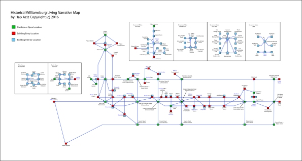
Revised Game Map
I’ve revised the game map slightly from the last published version. In this new map, there are some altered and additional paths between locations. Also, several of the buildings (represented by red squares) have interior rooms, providing more locations for exploration. These buildings are marked with the light blue circle around them. This map is being implemented in version 11 or the test program. I’ll have that version published soon for the HWLN Kickstarter backers.

The Game Begins: First Screens
Progress on the Historical Williamsburg Living Narrative continues. Three plot-level releases are planned: a walk-through version focused on the Williamsburg physical layout, an exploratory version including interaction and discovery with historical characters, and narrative version that is constructed around the removal of the gunpowder supply from the magazine.
The following two screenshots represent what the player will first encounter regardless of the version of the game being played. First is the pre-game opening screen that appears before the player provides any input. As you can see, it sets up a little bit of the story framework by providing some background on the player character and context on how he comes to be in Williamsburg.

The second screenshot depicts the description the player gets the second time this location is visited. (The first version of the description has some additional information and is displayed as soon as the player presses the Space bar at the intro screen.) As you can see, the command “see” was entered after the text description. The way the HWLN game is being implemented, graphic images will be provided at many locations; however, in order to display the images, the player must enter the “see” command at the prompt. The images themselves are based on my actual photography of Williamsburg.

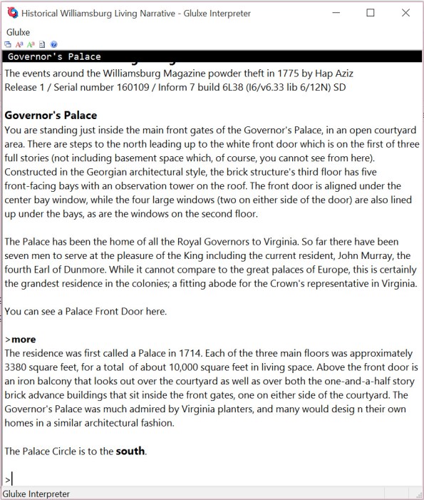
A Starting Screen
While I’m doing Glulxe testing, I thought I’d take one more screen shot of the game, this one all text. This is right after the game intro screen comes up, and the player presses the space bar to get into the game proper.
You’ll notice the first command issued by the player is followed by more descriptive text. “More” is a custom command I’ve added to the system that displays more detailed information about the location surroundings. Ultimately, it’s all to help the player make sense of the game.
Running on Glulxe
It’s quite easy to release Inform 7 games for the Glulxe interpreter, which in turn makes it easy to test. So that’s what I did to get this screen shot with the Capitol, and there’s a portion of descriptive text on the screen as well.

Streamlined Williamsburg Map
In my last blog post (Fun with Maps) I discussed the complexities around map development for Interactive Fiction, especially given the design tension between maintaining historical accuracy and fostering engaging gameplay. During my most recent trip to Williamsburg last September, I found that the Colonial Williamsburg Foundation helped address the map dilemma by issuing a simplified version of their visitor map. This is the visitor map that is currently being published (along with the daily events in the colonial city area).

I took this map and eliminated the extraneous information based on the actual game and story requirements. That gave me a very clean map from which to work. You can see that this map provides a layout of the relative positions of buildings, the streets they are on, and distance information.

Using this clean map, I marked the positions of the buildings and other navigation junctures that would be needed in (this version of) the game. Then I connect the locations where I wanted pathways, so that I could visualize the compass headings to use in terms of game commands. (You can see the blue lines connecting the red and green squares.)

Finally, I pulled the background out in order to have the unadorned map to use in building navigation functionality within Inform 7.
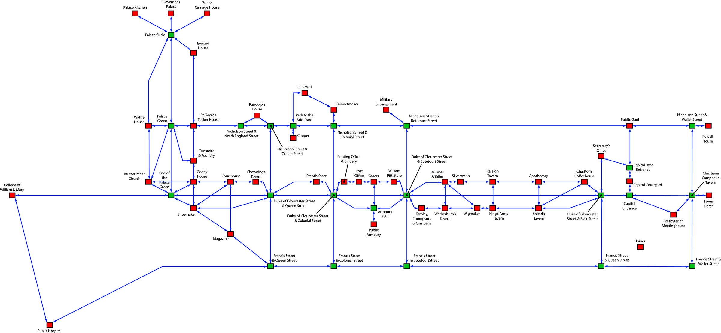
The red boxes represent buildings or structures that have further navigation within, while the green boxes are simply outside locations. Using this map, I was quickly able to create basic navigation in Inform 7, and I am using the map as a location checklist for the location descriptions. (Additionally, I am creating the logic in Inform 7 to handle multiple stops at the same location, and requests for more information regarding locations.
In addition, this map allowed me to visualize some navigational shortcuts to help with the flow of the game. For example, I’ve created a custom command “street” that functions at many of the building locations on the Duke of Gloucester Street (that’s the main street running from the College of William & Mary in the west to the Capitol Building in the east). When a player is at the entrance of one of those buildings, using the “street” command will take the player to one of a number of unmarked positions on the Duke of Gloucester Street, between the two cross streets that apply to the building where the player is. From the unmarked position, the player can see the buildings up and down between the cross streets and choose to navigate directly to any of them. These unmarked positions on the Duke of Gloucester Street are not accessible through standard compass-direction navigation.
Within the next week or two, I’ll have a robust version of the game navigation completed in Inform 7 and available for download to the original Kickstarter backers.
HWLN Perks and Progress Update
For those of you that have backed the Historical Williamsburg Living Narrative Project through Kickstarter, the following is information regarding some of the perks. For everyone, here is information also on the progress of the project.
Today and tomorrow, the digital photos and the printed 8×10 photos are going out to the appropriate level backers. Regarding the digital photos, I will be posting a link where you can go and download the photos you would like to have. The are provided in high resolution, suitable for printing if you choose. You will receive the link via email today (12/27/15).
For the printed 8×10 signed photos, I will be sending those tomorrow via first class U.S. mail. Several backers have not yet provided physical mailing addresses, so please check your inbox and junk/spam folder for the survey so you may provide your address. If you prefer, you may contact me directly with your mailing address.
I have resumed work on the game, and currently I am developing interior building descriptions. In the interest of historical accuracy, I am working from photographs I have taken of the building interiors as well as descriptions recorded in research reports available through the Colonial Williamsburg Rockefeller Library: http://research.history.org/.
Navigation QA: Checking the Map
It’s been a while since the last update, as I’ve had several projects eat into my time both for work and for my dissertation. As it turns out, the dissertation is giving me the excu–uh, reason to reapply some focus on the Historical Williamsburg Living Narrative. I’ll need to have a simple version of the game up and running to provide to instructors willing to use the game in the classroom. That means I need to work on it.
I’ve gone back and forth and back again on the development tool to use for the project, from Inform 7 to Adrift to LiveCode, and right now I’m settled on LiveCode for the amount of control I have in building the interface and interaction framework for the game. Currently I’ve developed a simple version of the program that does nothing but navigate through the map, currently 199 separate locations, using abbreviated compass directions: n, ne, e, se, s, sw, w, and nw. The map is below, and you can access a PDF version: Logical Map – Nav Test.

Of course, you will need to actual program to run as well, if you’re interested in checking out the navigation. You may obtain that by accessing it by clicking this link. The file is a Windows version program Zip compressed for faster download. If you’re interested in a Mac version, leave a comment and I’ll compile a version for download.
If you intent to perform quality assurance testing and provide feedback, simply leave comments in response to this post. Be sure to list the error you found, how you encountered the error, and what the error does or doesn’t do. Most likely, errors at this stage will be discrepancies between the visual map and the navigational structure within the program. The visual map (above) is correct; the program will need to be corrected if any discrepancies are found.
One final note: anyone finding errors in the program will be listed as QA testers, being listed in the release version credits. So have at it!
The Peyton Randolph House
One of the locations that will be an area for exploration and interaction within the game is the Peyton Randolph House. Peyton Randolph (1721-1775) was a key figure in American history, and had he not died in the fall of 1775, it is likely that his signature, not John Hancock’s, would be iconic on the Declaration of Independence.
While much of the floor plan research has been possible through architectural documents from the Colonial Williamsburg Foundation, I discovered that the Randolph house historical layout was not well documented. Last week I was able to travel to Williamsburg for a quick visit and tour the building. I took a number of photographs and sketched out the floor plan on a pad of graph paper to capture the layout. I’ll post some of the pictures here shortly.
Another piece in place. While the progress is slower than I’d like, the movement is forward!
