Archive
Running on Glulxe
It’s quite easy to release Inform 7 games for the Glulxe interpreter, which in turn makes it easy to test. So that’s what I did to get this screen shot with the Capitol, and there’s a portion of descriptive text on the screen as well.

Streamlined Williamsburg Map
In my last blog post (Fun with Maps) I discussed the complexities around map development for Interactive Fiction, especially given the design tension between maintaining historical accuracy and fostering engaging gameplay. During my most recent trip to Williamsburg last September, I found that the Colonial Williamsburg Foundation helped address the map dilemma by issuing a simplified version of their visitor map. This is the visitor map that is currently being published (along with the daily events in the colonial city area).

I took this map and eliminated the extraneous information based on the actual game and story requirements. That gave me a very clean map from which to work. You can see that this map provides a layout of the relative positions of buildings, the streets they are on, and distance information.

Using this clean map, I marked the positions of the buildings and other navigation junctures that would be needed in (this version of) the game. Then I connect the locations where I wanted pathways, so that I could visualize the compass headings to use in terms of game commands. (You can see the blue lines connecting the red and green squares.)

Finally, I pulled the background out in order to have the unadorned map to use in building navigation functionality within Inform 7.
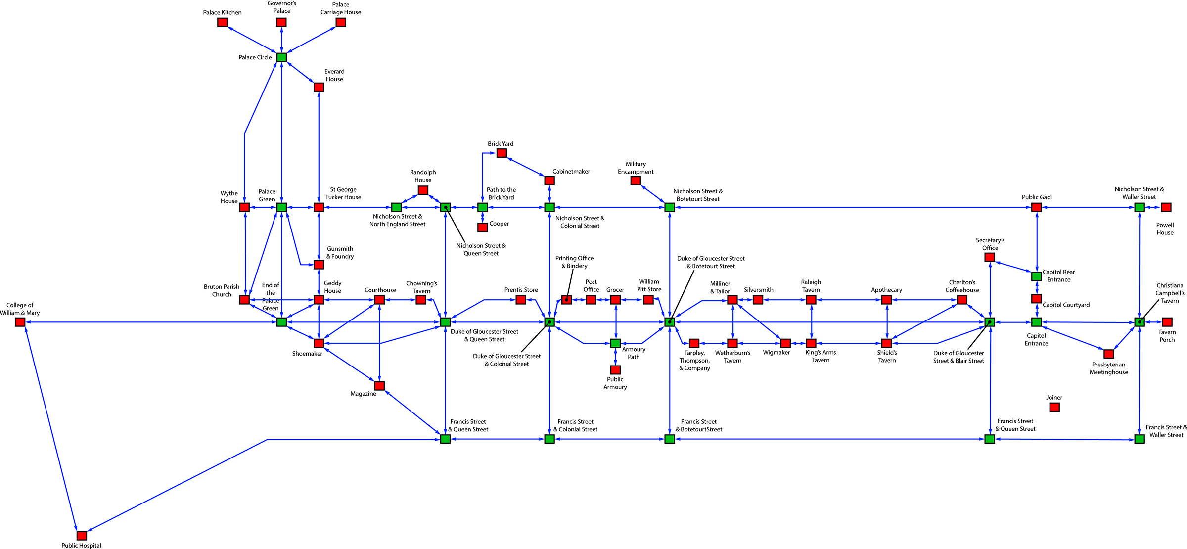
The red boxes represent buildings or structures that have further navigation within, while the green boxes are simply outside locations. Using this map, I was quickly able to create basic navigation in Inform 7, and I am using the map as a location checklist for the location descriptions. (Additionally, I am creating the logic in Inform 7 to handle multiple stops at the same location, and requests for more information regarding locations.
In addition, this map allowed me to visualize some navigational shortcuts to help with the flow of the game. For example, I’ve created a custom command “street” that functions at many of the building locations on the Duke of Gloucester Street (that’s the main street running from the College of William & Mary in the west to the Capitol Building in the east). When a player is at the entrance of one of those buildings, using the “street” command will take the player to one of a number of unmarked positions on the Duke of Gloucester Street, between the two cross streets that apply to the building where the player is. From the unmarked position, the player can see the buildings up and down between the cross streets and choose to navigate directly to any of them. These unmarked positions on the Duke of Gloucester Street are not accessible through standard compass-direction navigation.
Within the next week or two, I’ll have a robust version of the game navigation completed in Inform 7 and available for download to the original Kickstarter backers.
Fun with Maps

Maps are essential to many Interactive Fiction games, especially those that involve activity in various locations. Interactive Fiction game maps that deal with real locations, however, are challenging to implement, as there is a trade-off to be had between realism and playability. If the design is meant to represent the physical layout with utmost fidelity, the details of the map can potentially slow down and frustrate game play as the player is forced to move from one seemingly meaningless location to another in order to get to the desired destination. It’s similar to the counterpoint between a flight simulator and a flight game–the realism of a true simulator can be very boring, unless it’s the simulation itself that interests you.
Likewise, the conflicting visions of the HWLN: is it a simulation of the physical layout of Williamsburg as it was in the months leading up the signing of the Declaration of Independence, or is it a game about the events taking place during that time? That conflict plays itself out everytime I return to the map and struggle with the appropriate level of detail to include. I’ve been wanting the game to be both, but that may not be the wisest choice for the HWLN as a game.
Part of the challenge was addressed in part by the new daily maps published by the Colonial Williamsburg Foundation for visitors. The new map (show in the picture above) is actually a streamlined version of an earlier visitor map which you can view here. The older map is much more detailed, and perhaps in the Colonial Williamsburg Foundation’s thinking, it was not as user friendly. Whatever the case, the new map gives me a good template for a more streamlined game map, on which I am currently working and will implement at least initially in Inform 7.
So for the sake of playability, I’ll work with a less detailed map. But at some point, as an exercise in modeling an accurate picture of history, I’ll return to the “high resolution” version in order to satisfy my inner purist.
