Archive
Game Navigation Structure Completed…
… for the most part, anyway!
I’ve completed the navigation structure for the game including all the exterior locations as well as building interiors. I’ll publish the release soon for backer downloading. Timing-wise, I’m heading to Williamsburg with the family to spend a week there over Christmas vacation. This will give me an opportunity to do more interior research for more interesting (as well as accurate) descriptions. In the mean time, below is the latest game map.

Latest Playable Release – HWLN12
This report recently went out to all of the game Backers on Kickstarter. The actual download location is available only to the Backers.
**********
Greetings, Backers!
I new version is available for download at [URL HIDDEN]. Included in the .zip archive is a map of the locations.
A quick word about the map: where you see the location names highlighted in blue, the blue portions indicate a shortcut in the game navigation system (meant for speedier play testing only). For example, on the map is the “Military Encampment” location with the word “Military” in blue. When you are playing the game, type “xmilitary” at the cursor and you will be immediately taken to the Military Encampment. This will work for any of the locations in blue.
A big “thank you” goes to backer Vivianne D. for her work on the navigation code in Inform 7. Now when you type “dir” at the cursor, the game will display all possible directions (unless specifically hidden) based on room relative location definitions. Previously, I had been hand coding all those directions.
Otherwise, changes in this version are not major. Cleaned up more descriptions, added some detail, etc. Feel free to play it and let me know what you find.
In an upcoming release I will be publishing a guide that provides a listing of the possible commands.
Hap
Latest Playable Version
A quick update: there is a new playable version of the game available for backers of the original Kickstarter project. Here’s what I shared in a message to the backers (removing the access instructions for the actual game).
This version includes some minor navigation/map description updates. The main change here is in the addition of some non-player characters (NPCs).
The NPCs are implement in a very basic capacity, and they are not in their final game locations. Dialog is limited, but you can test them out using the “ask [character] about [noun]” format. You will find:
- a farmer – in the Palace Green. You can use the command “ask the farmer about Anderson’s” when you encounter him to see what happens.
- a cordwainer – ask him about shoes when you find him.
- George Wythe (no dialog)
- Thomas Jefferson
- Patrick Henry
For Jefferson, Henry, and the farmer, there is additional dialog, but I won’t say here. It’s not likely you’ll be able to guess what to ask them about (though if you know Williamsburg histry you may be able to figure it out). Don’t worry about that, as the context of the game events will give you clues/hints.
In the meantime, if you do playtest (or even if you don’t), feel free to let me know what kinds of things (nouns) you might ask about and expect to get some sort of answer. Your feedback will give me good player’s perspective.
More NPCs will be added, along with greater dialog vocabulary. Other considerations will be making dialog dependent on time of day, location, and even what the player may have learned from other characters or in discovering certain things about the environment. NPCs will not be “stuck” in the same location, and the time of day will determine where they are.
Other Historical Communities and Locations
While historical Williamsburg (as managed by the Colonial Williamsburg Foundation) has been my focus, there are other historical communities, sites, and museums that are definitely worth visiting. A few that I want to mention here are
- Deerfield, Massachussetts – an authentic 18th-century New England village in the Connecticut River Valley of Massachusetts
- Gettysburg, Pennsylvania – site of one of the most famous battles of the American Civil War
- Monticello – Thomas Jefferson’s home and plantation in Charlottesville, Virginia
- Mount Vernon – The Virginia home to the first President of the United States, George Washington
- Winterthur, Delaware – a rich museum of American decorative arts that reflects both early America and the life of the du Pont family
The Game Begins: First Screens
Progress on the Historical Williamsburg Living Narrative continues. Three plot-level releases are planned: a walk-through version focused on the Williamsburg physical layout, an exploratory version including interaction and discovery with historical characters, and narrative version that is constructed around the removal of the gunpowder supply from the magazine.
The following two screenshots represent what the player will first encounter regardless of the version of the game being played. First is the pre-game opening screen that appears before the player provides any input. As you can see, it sets up a little bit of the story framework by providing some background on the player character and context on how he comes to be in Williamsburg.

The second screenshot depicts the description the player gets the second time this location is visited. (The first version of the description has some additional information and is displayed as soon as the player presses the Space bar at the intro screen.) As you can see, the command “see” was entered after the text description. The way the HWLN game is being implemented, graphic images will be provided at many locations; however, in order to display the images, the player must enter the “see” command at the prompt. The images themselves are based on my actual photography of Williamsburg.

A Starting Screen
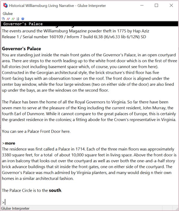
While I’m doing Glulxe testing, I thought I’d take one more screen shot of the game, this one all text. This is right after the game intro screen comes up, and the player presses the space bar to get into the game proper.
You’ll notice the first command issued by the player is followed by more descriptive text. “More” is a custom command I’ve added to the system that displays more detailed information about the location surroundings. Ultimately, it’s all to help the player make sense of the game.
Graphic Enhancement to Traditional IF
The Interactive Fiction I grew up on (starting with the Scott Adams text adventures that I got in cassette form for my TI 99/4A computer) was all text based. No graphics at all; just two-word phrases that eventually turned into more sophisticated Infocom game sentences, but still words only. In fact, one of my favorite computer game ads was the Infocom print ad that said something to the effect of “We stick our graphics where the sun don’t shine,” and then there was a picture of the human brain. Pretty clever, and you can see it here.
One of the characteristics that makes Inform 7 so appealing as an IF development environment is that it allows a person to rapidly put together an IF game in the form of those old Infocom games: a pretty robost parser that allowed for sentence input. However, Inform 7 has made a number of improvements to the output it produces, compared to the earlier Infocom games. One of those improvements is the ability to integrate graphic images into the Inform code for display when someone plays the game.
I’ve decided to take advantage of this feature during development of the Historical Williamsburg Living Narrative. I’ll be using the photographs I have taken of Williamsburg, and I’ll have the photographs changed into a more comic-like illustration. Below is a sample of the Capitol Building already having gone through the image processing.
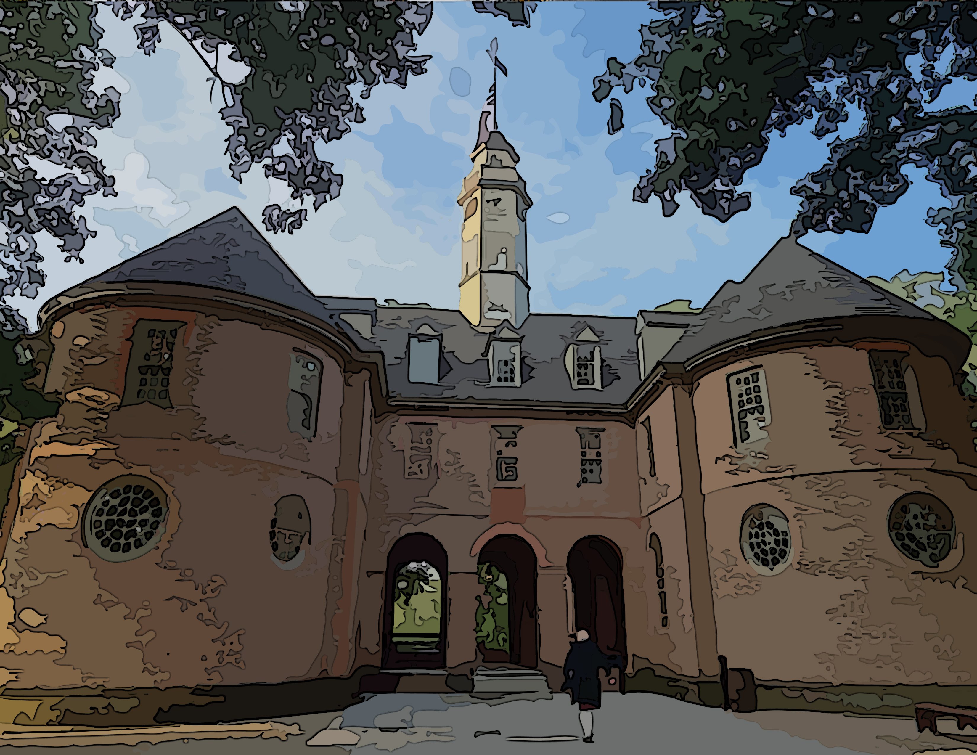
As you can see, the photograph has been altered to appear as more of an illustration. I’ll do this for all of the photographs to be used in the game. Please share your thoughts: do you like this approach to Interactive Fiction? Or does IF need to be more “old school”?
Streamlined Williamsburg Map
In my last blog post (Fun with Maps) I discussed the complexities around map development for Interactive Fiction, especially given the design tension between maintaining historical accuracy and fostering engaging gameplay. During my most recent trip to Williamsburg last September, I found that the Colonial Williamsburg Foundation helped address the map dilemma by issuing a simplified version of their visitor map. This is the visitor map that is currently being published (along with the daily events in the colonial city area).

I took this map and eliminated the extraneous information based on the actual game and story requirements. That gave me a very clean map from which to work. You can see that this map provides a layout of the relative positions of buildings, the streets they are on, and distance information.

Using this clean map, I marked the positions of the buildings and other navigation junctures that would be needed in (this version of) the game. Then I connect the locations where I wanted pathways, so that I could visualize the compass headings to use in terms of game commands. (You can see the blue lines connecting the red and green squares.)

Finally, I pulled the background out in order to have the unadorned map to use in building navigation functionality within Inform 7.
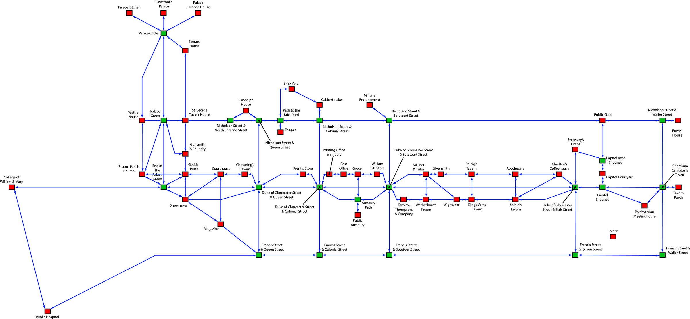
The red boxes represent buildings or structures that have further navigation within, while the green boxes are simply outside locations. Using this map, I was quickly able to create basic navigation in Inform 7, and I am using the map as a location checklist for the location descriptions. (Additionally, I am creating the logic in Inform 7 to handle multiple stops at the same location, and requests for more information regarding locations.
In addition, this map allowed me to visualize some navigational shortcuts to help with the flow of the game. For example, I’ve created a custom command “street” that functions at many of the building locations on the Duke of Gloucester Street (that’s the main street running from the College of William & Mary in the west to the Capitol Building in the east). When a player is at the entrance of one of those buildings, using the “street” command will take the player to one of a number of unmarked positions on the Duke of Gloucester Street, between the two cross streets that apply to the building where the player is. From the unmarked position, the player can see the buildings up and down between the cross streets and choose to navigate directly to any of them. These unmarked positions on the Duke of Gloucester Street are not accessible through standard compass-direction navigation.
Within the next week or two, I’ll have a robust version of the game navigation completed in Inform 7 and available for download to the original Kickstarter backers.
Fun with Maps

Maps are essential to many Interactive Fiction games, especially those that involve activity in various locations. Interactive Fiction game maps that deal with real locations, however, are challenging to implement, as there is a trade-off to be had between realism and playability. If the design is meant to represent the physical layout with utmost fidelity, the details of the map can potentially slow down and frustrate game play as the player is forced to move from one seemingly meaningless location to another in order to get to the desired destination. It’s similar to the counterpoint between a flight simulator and a flight game–the realism of a true simulator can be very boring, unless it’s the simulation itself that interests you.
Likewise, the conflicting visions of the HWLN: is it a simulation of the physical layout of Williamsburg as it was in the months leading up the signing of the Declaration of Independence, or is it a game about the events taking place during that time? That conflict plays itself out everytime I return to the map and struggle with the appropriate level of detail to include. I’ve been wanting the game to be both, but that may not be the wisest choice for the HWLN as a game.
Part of the challenge was addressed in part by the new daily maps published by the Colonial Williamsburg Foundation for visitors. The new map (show in the picture above) is actually a streamlined version of an earlier visitor map which you can view here. The older map is much more detailed, and perhaps in the Colonial Williamsburg Foundation’s thinking, it was not as user friendly. Whatever the case, the new map gives me a good template for a more streamlined game map, on which I am currently working and will implement at least initially in Inform 7.
So for the sake of playability, I’ll work with a less detailed map. But at some point, as an exercise in modeling an accurate picture of history, I’ll return to the “high resolution” version in order to satisfy my inner purist.
